Mapping Archival Architecture Records
Interdisciplinary Research and Approach with GIS Technologies
DOI:
https://doi.org/10.15353/acmla.n176.6752Keywords:
ArcGIS Dashboards, Archival Research, Architecture, Research Methods, Mapping, Historic RecordsAbstract
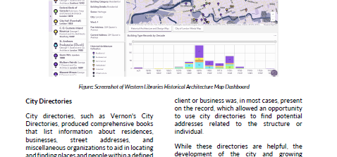
The Murphy Moore Collection comprises over 2000 architectural plans, drawings, and correspondence with individuals involved in John M. Moore's work and the firm's various iterations, as well as material from other London-based architects. The plans are primarily focused in London, Ontario, but expand across Southern Ontario and include illustrations of residential, industrial, commercial, and ecclesiastical buildings–some of which are still present. Traditionally kept as text-based metadata records, this catalogue was transformed using ArcGIS program Dashboards to create an interactive user interface that encourages active discovery. However, to connect these records to their geographical location, various archival research methods such as the use of city directories, fire insurance plans, maps, and historical photography were used to accurately display these records.
References
Belton, T., (2019) "Using GIS and Mapping Tools to Access and Visualize Archival Records: Case Studies and Survey Results of North American Archivists and Historians", Archival Issues 39(2), 22–45. doi: https://doi.org/10.31274/archivalissues.11073
Canadiana. (1895). The London City and Middlesex County Directory 1895. https://www.canadiana.ca/view/oocihm.8_00135_10/341
Google Street View (2021). 2 The Ridgeway. Google Maps. 2 The Ridgeway
Grainger, J. (2017). London free press : from the vault. Biblioasis.
Jason A. Gilliland, & Mathew Novak. (2006). Jason A. Gilliland and Mathew Novak on Positioning the Past with the Present: The Use of Fire Insurance Plans and GIS for Urban Environmental History. Environmental History, 11(1), 136–139. http://www.jstor.org/stable/3985742
Murphy, D. R., Durand, G. F., Robinson, W., Moore, J. M., Moore, O. R., Murphy, R. E., & Tracy, T. H. (1922). The Murphy - Moore architectural archives collection. Murphy & Murphy Architect Inc.
Rayfield, Jo Ann. (1991). "Using City Directories to Teach History and Historical Research Methods". Teaching History: A Journal of Methods 16 (1):14-26. https://doi.org/10.33043/TH.16.1.14-26.
Tatomir, J., & Durrance, J. C. (2010). Overcoming the information gap: Measuring the accessibility of library databases to adaptive technology users. Library Hi Tech, 28(4), 577–594. https://doi.org/10.1108/07378831011096240
Tausky, N. & DiStefano, L. (1986). CHAPTER FIVE. The Moore Era. In Victorian Architecture in London and Southwestern Ontario: Symbols of Aspiration (pp. 353-442). Toronto: University of Toronto Press. https://doi.org/10.3138/9781487584030-006
Western Archives. (2013). How to Research Older or Historic Buildings. https://www.lib.uwo.ca/files/archives/Research_Heritage_Buildings_Brochure-May2.pdf
Western Library. (1922). Insurance Plan of the City of London. 1912 Rev. 1922 insurance plan of the City of London, Ontario. https://www.lib.uwo.ca/madgic/projects/fips/london_fip_1922/index.html
Western Libraries. (2022). Strategic Plan. Western Libraries. https://www.lib.uwo.ca/files/aboutwl/strategicplan-2022-2028.pdf
Western University. (2021). AODA: Making Western's Accessible Web. Western Communications. https://www.communications.uwo.ca/pdf/Western-AODA-Accessibility-Slim.pdf
Downloads
Published
How to Cite
Issue
Section
License
Copyright (c) 2025 Marina (Mars) Brint

This work is licensed under a Creative Commons Attribution-NonCommercial 4.0 International License.
Authors retain the copyright to their work by using Creative Commons licenses. The Creative Commons Attribution-NonCommercial license applies to all content unless authors elect to choose a more restrictive license for their work. If you reuse the content, you must give appropriate credit; you may not use or redistribute the material for commercial purposes.