
Publishing historical air photos in Alma Digital
A case study featuring the University of Ottawa Library’s new DAMS
DOI:
https://doi.org/10.15353/acmla.n173.5670Keywords:
Aerial imagery, air photos, Alma Digital, DAMS, digital repository, Omni, special collectionsAbstract
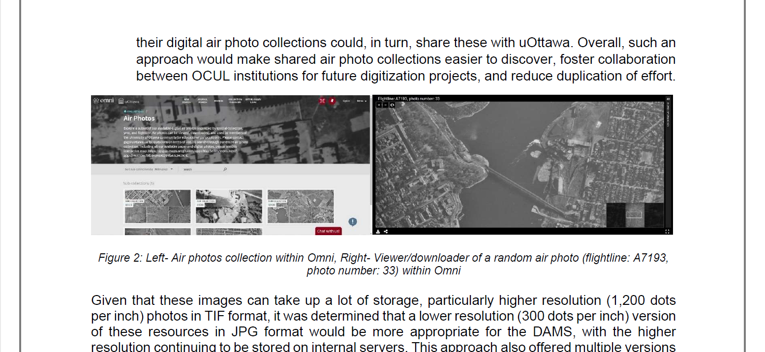
Air photos have been used to support GIS-related research projects at the University of Ottawa, particularly in the field of climate science. The University of Ottawa Library houses a large collection of historical paper air photos and have recently increased efforts to further digitize this collection. Traditionally, the photographs have been searchable through a custom ArcGIS Online Web App, but this standalone portal has been limited in the accessibility and discoverability of these resources. In 2021, the University of Ottawa Library implemented Alma Digital as its institutional DAMS, which allowed its digital assets to be searchable directly within the library catalog, Omni. Following the implementation of this DAMS, close to 1,000 of the Library’s digital air photo collection were added to this platform. This has provided a new discovery portal for these digital air photos. Work to improve the discoverability, organization, and description of these resources, as well as numerous digitization projects, is still ongoing.
References
Carbonetto, K. (1983). The National Air Photo Library. Urban History Review / Revue d'histoire urbaine, 12(1), 67–72. https://doi.org/10.7202/1018997ar
Carvalho, R. C., & Reef, R. (2022). Quantification of Coastal Change and Preliminary Sediment Budget Calculation Using SfM Photogrammetry and Archival Aerial Imagery. Geosciences (Basel), 12(10), 357-. https://doi.org/10.3390/geosciences12100357
The Collection at National Air Photo Library. (2022, April 25). Government of Canada. Retrieved March 21, 2024, from https://natural-resources.canada.ca/maps-tools-and-publications/satellite-imagery-and-air-photos/air-photos/national-air-photo-library/collection-national-air-photo-library/9693
Gomez, C., Hayakawa, Y., & Obanawa, H. (2015). A Study of Japanese Landscapes Using Structure From Motion Derived DSMs and DEMs Based on Historical Aerial Photographs: New Opportunities for Vegetation Monitoring and Diachronic Geomorphology. Geomorphology (Amsterdam, Netherlands), 242, 11–20. https://doi.org/10.1016/j.geomorph.2015.02.021
Kaplan, D. (2009). Choosing a Digital Asset Management System That’s Right for You. Journal of Archival Organization, 7(1–2), 33–40. https://doi.org/10.1080/15332740902897360
Knuth, F., Shean, D., Bhushan, S., Schwat, E., Alexandrov, O., McNeil, C., Dehecq, A., Florentine, C., & O’Neel, S. (2023). Historical Structure From Motion (HSfM): Automated Processing of Historical Aerial Photographs for Long-Term Topographic Change Analysis. Remote Sensing of Environment, 285, 113379-. https://doi.org/10.1016/j.rse.2022.113379
Kochtitzky, W., Jiskoot, H., Copland, L., Enderlin, E., McNabb, R., Kreutz, K. and Main, B. (2019). Terminus Advance, Kinematics, and Mass Redistribution During Eight Surges of Donjek Glacier, St. Elias Range, Canada, 1935 to 2016. Journal of Glaciology, 65(252), 565-579. https://doi.org/10.1017/jog.2019.34
Kochtitzky, W., Copland, L., Painter, M. and Dow, C. (2020). Draining and Filling of Ice Dammed Lakes at the Terminus of Surge-Type Dań Zhùr (Donjek) Glacier, Yukon, Canada. Canadian Journal of Earth Sciences, 57, 1337-1348. https://doi.org/10.1139/cjes-2019-0233
Laboratory for Cryospheric Research (n.d.). Dept of Geography, Environment & Geomatics, University of Ottawa. Retrieved March 6, 2024 from https://cryospheric.org/
Millard, K., Redden, A. M., Webster, T., & Stewart, H. (2013). Use of GIS and High Resolution LiDAR in Salt Marsh Restoration Site Suitability Assessments in the Upper Bay of Fundy, Canada. Wetlands Ecology and Management, 21(4), 243–262. https://doi.org/10.1007/s11273-013-9303-9
Roberti, G., Ward, B. C., van Wyk deVries, B., Perotti, L., Giardino, M., Friele, P. A., Clague, J. J., Menounos, B., Anderson, L. S., & Freschi, S. (2021). Structure From Motion Used to Revive Archived Aerial Photographs for Geomorphological Analysis; An Example From Mount Meager Volcano, British Columbia, Canada. Canadian Journal of Earth Sciences, 58(12), 1253–1267. https://doi.org/10.1139/cjes-2020-0140
Schaffer, N., Copland, L. and Zdanowicz, C. (2017). Ice Velocity Changes on Penny Ice Cap, Baffin Island, Since the 1950s. Journal of Glaciology, 63(240), 716-730. doi: 10.1017/jog.2017.40
Strategic plan 2025 (n.d.). uOttawa Library. Retrieved March 4, 2024, from https://www.uottawa.ca/library/strategic-plan
Downloads
Published
How to Cite
Issue
Section
License
Copyright (c) 2024 René Duplain

This work is licensed under a Creative Commons Attribution-NonCommercial 4.0 International License.
Authors retain the copyright to their work by using Creative Commons licenses. The Creative Commons Attribution-NonCommercial license applies to all content unless authors elect to choose a more restrictive license for their work. If you reuse the content, you must give appropriate credit; you may not use or redistribute the material for commercial purposes.